 ©Hellotravellers

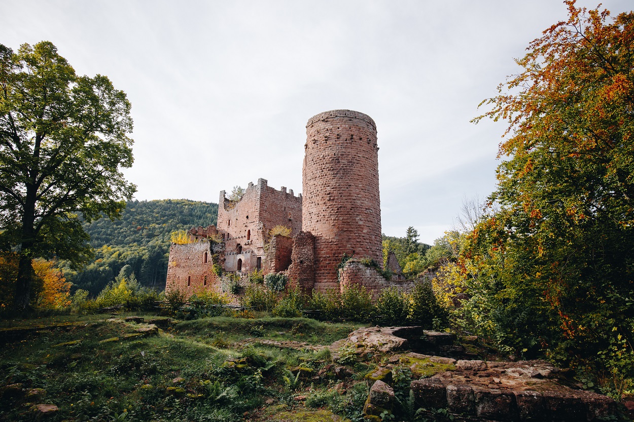
Hiking trail - The Ottrott Castles
Circuits, sentiers et itinéraires
Place de la gare - 67530 Ottrott
03 88 50 75 38 - contact@mso-tourisme.com
www.mso-tourisme.com


The “Portes Bonheur, chemin des carrières” Greenway, which stretches for 11 km from Rosheim to Saint-Nabor, also offers the opportunity to leave the main route and explore other viewpoints and landscapes along a circular trail, providing new perspectives on the surrounding scenery.
The "Tour of the Ottrott Castles" starts at the Ottrott station from the Green Way. Discover the castles of Lutzelbourg and Rathsamhausen and enjoy a view of Mont Sainte-Odile!
Departure: Place de la gare.
Parking possible: Parking Place de la gare.
A hike accessible without a car via bus route 257. Get off at the ‘Ancienne gare’ stop.
o
Location :
- In the forest
- Shaded
- Panoramic view
Length of visit/event :
3hLevel of difficulty :
IntermediateDistance (km) to the nearest station :
5location
Calculate itinerary:
Venue of the event :
Lion's Gate in RosheimLabels
u
Access
Nearest train station 5 kmName : Obernai
Level of difficulty :
IntermediateLength of visit/event :
3hDifference in altitude (in m) :
284Length of the itinerary :
8,3This might interest you too
Greenway "Portes Bonheur, the Quarry Trail "
Rosheim+
Hiking trail - Through vineyards and orchards
Rosheim+
Hiking trail - The Abbeys Circuit
Saint Nabor+
Hiking trail - The Bischenberg Circuit
Rosheim+
Hiking trail - From Boersch to Obernai
Boersch+
Hiking trail - From the gates of Boersch to St-Léonard
Boersch+
Hiking trail - The Westerberg Circuit
Rosheim+
Cycling tour - Mont Sainte-Odile
Rosheim+
Cycling tour - the Eichwald
Rosheim+
Cycling tour - Around Rosheim
Rosheim+
Cycling tour - around the Voie Verte
Rosheim+
Array
(
[id] => 258003159
[nom] => Hiking trail - The Ottrott Castles
[type] => Array
(
[id] => 1900316
[nom] => Circuits, sentiers et itinéraires
)
[entite_gestionnaire] => 258
[nom_entite_gestionnaire] => Office de tourisme intercommunal du Mont Sainte-Odile
[coordonnees] => Array
(
[libelle_voie] => Place de la gare
[code_postal] => 67530
[libelle_commune] => Ottrott
[telephone1] => 03 88 50 75 38
[email1] => contact@mso-tourisme.com
[url1] => www.mso-tourisme.com
[pays] => FRANCE
)
[insee] => 67368
[type_georeferencement] => 2
[libelle_georeferencement] => précis
[latitude] => 48,4607469582332
[longitude] => 7,43420448051758
[commentaire] => The “Portes Bonheur, chemin des carrières” Greenway, which stretches for 11 km from Rosheim to Saint-Nabor, also offers the opportunity to leave the main route and explore other viewpoints and landscapes along a circular trail, providing new perspectives on the surrounding scenery.
<br><br>
The "Tour of the Ottrott Castles" starts at the Ottrott station from the Green Way. Discover the castles of Lutzelbourg and Rathsamhausen and enjoy a view of Mont Sainte-Odile! <br> <br>
Departure: Place de la gare.<br>
Parking possible: Parking Place de la gare.<br>
A hike accessible without a car via bus route 257. Get off at the ‘Ancienne gare’ stop.
[prestataire] => Array
(
[raison_sociale] =>
[civilite] =>
[nom] =>
[prenom] =>
[fonction] =>
[coordonnees] => Array
(
[num_voie] => 1
[libelle_voie] => rue Saint-Benoît
[distri_speciale] =>
[code_postal] => 67560
[libelle_commune] => Rosheim
[telephone1] => 03 88 50 75 38
[telephone2] =>
[telephone3] =>
[fax] =>
[email1] =>
[email2] =>
[url1] =>
[url2] =>
[pays] => FRANCE
)
)
[debut_validite] => 09/03/2020
[fin_validite] => 31/12/2050
[marquage] => 0
[datmaj] => 21/06/2026 10:09:59
[datecreation] => 03/07/2020 14:32:40
[horaires] => Array
(
)
[produits_associes] => Array
(
[0] => Array
(
[id] => 258002951
[nom] => Greenway "Portes Bonheur, the Quarry Trail "
[id_type] => 1900316
[type_couplage] => 10
)
[1] => Array
(
[id] => 258003133
[nom] => Hiking trail - Through vineyards and orchards
[id_type] => 1900316
[type_couplage] => 10
)
[2] => Array
(
[id] => 258003152
[nom] => Hiking trail - The Abbeys Circuit
[id_type] => 1900316
[type_couplage] => 10
)
[3] => Array
(
[id] => 258003160
[nom] => Hiking trail - The Bischenberg Circuit
[id_type] => 1900316
[type_couplage] => 10
)
[4] => Array
(
[id] => 258003186
[nom] => Hiking trail - From Boersch to Obernai
[id_type] => 1900316
[type_couplage] => 10
)
[5] => Array
(
[id] => 258003187
[nom] => Hiking trail - From the gates of Boersch to St-Léonard
[id_type] => 1900316
[type_couplage] => 10
)
[6] => Array
(
[id] => 258003188
[nom] => Hiking trail - The Westerberg Circuit
[id_type] => 1900316
[type_couplage] => 10
)
[7] => Array
(
[id] => 258003189
[nom] => Cycling tour - Mont Sainte-Odile
[id_type] => 1900316
[type_couplage] => 10
)
[8] => Array
(
[id] => 258003190
[nom] => Cycling tour - the Eichwald
[id_type] => 1900316
[type_couplage] => 10
)
[9] => Array
(
[id] => 258003192
[nom] => Cycling tour - Around Rosheim
[id_type] => 1900316
[type_couplage] => 10
)
[10] => Array
(
[id] => 258003193
[nom] => Cycling tour - around the Voie Verte
[id_type] => 1900316
[type_couplage] => 10
)
)
[criteres] => Array
(
[0] => Array
(
[id] => 900000
[nom] => Secteur
[type_critere] => -1
[type_valeur] => 2
[classe] => 0
[modalites] => Array
(
[0] => Array
(
[id] => 1912775
[nom] => CC des Portes de Rosheim
[ordre] => 0
)
[1] => Array
(
[id] => 1903852
[nom] => Région
[ordre] => 0
)
)
)
[1] => Array
(
[id] => 900002
[nom] => Tracé KML
[type_critere] => 0
[type_valeur] => 6
[classe] => 2
[valeur] => https://apps.tourisme-alsace.info/traces/258003159.kml
)
[2] => Array
(
[id] => 900007
[nom] => Tracé GPX
[type_critere] => 0
[type_valeur] => 6
[classe] => 2
[valeur] => https://apps.tourisme-alsace.info/traces/258003159.gpx
)
[3] => Array
(
[id] => 1900013
[nom] => Distance (km) to the nearest station
[type_critere] => 0
[type_valeur] => 1
[classe] => 2
[valeur] => 5
)
[4] => Array
(
[id] => 1900179
[nom] => Classification Flowered Villages
[type_critere] => 1
[type_valeur] => 2
[classe] => 1
[modalites] => Array
(
[0] => Array
(
[id] => 1900894
[nom] => 3 flowers
[ordre] => 3
)
)
)
[5] => Array
(
[id] => 1900189
[nom] => Location
[type_critere] => -1
[type_valeur] => 2
[classe] => 2
[modalites] => Array
(
[0] => Array
(
[id] => 1908044
[nom] => In the forest
[ordre] => 175
)
[1] => Array
(
[id] => 1912255
[nom] => Shaded
[ordre] => 265
)
[2] => Array
(
[id] => 1901211
[nom] => Panoramic view
[ordre] => 350
)
)
)
[6] => Array
(
[id] => 1900219
[nom] => Venue of the event
[type_critere] => 0
[type_valeur] => 2
[classe] => 2
[valeur] => Lion's Gate in Rosheim
)
[7] => Array
(
[id] => 1900358
[nom] => A transmettre pour Internet
[type_critere] => 1
[type_valeur] => 2
[classe] => 0
[modalites] => Array
(
[0] => Array
(
[id] => 1902207
[nom] => Yes
[ordre] => 1
)
)
)
[8] => Array
(
[id] => 1900421
[nom] => Photo URL
[type_critere] => 0
[type_valeur] => 6
[classe] => 0
[valeur] => https://apps.tourisme-alsace.info/photos/rosheim/photos/258003159_12.jpg
)
[9] => Array
(
[id] => 1900461
[nom] => Secteur carte
[type_critere] => -1
[type_valeur] => 2
[classe] => 0
[modalites] => Array
(
[0] => Array
(
[id] => 1911639
[nom] => Alsace (site Alsace)
[ordre] => 0
)
[1] => Array
(
[id] => 1909895
[nom] => Vélo Colmar et centre Alsaceet nord
[ordre] => 0
)
[2] => Array
(
[id] => 1909236
[nom] => Oenotourisme - Coeur d'Alsace
[ordre] => 0
)
[3] => Array
(
[id] => 1909124
[nom] => Massif Vosges - Vosges centrales
[ordre] => 0
)
[4] => Array
(
[id] => 1908571
[nom] => Route des vins (site Alsace)
[ordre] => 0
)
[5] => Array
(
[id] => 1908335
[nom] => Massif des Vosges
[ordre] => 0
)
[6] => Array
(
[id] => 1906976
[nom] => Site Barr à proximité
[ordre] => 0
)
[7] => Array
(
[id] => 1903506
[nom] => Obernai
[ordre] => 0
)
)
)
[10] => Array
(
[id] => 1900463
[nom] => Villages label
[type_critere] => -1
[type_valeur] => 2
[classe] => 1
[modalites] => Array
(
[0] => Array
(
[id] => 1903444
[nom] => Approved "green stop" villages
[ordre] => 60
)
)
)
[11] => Array
(
[id] => 1900480
[nom] => Photo caption
[type_critere] => 0
[type_valeur] => 2
[classe] => 0
[valeur] => ©Hellotravellers
)
[12] => Array
(
[id] => 1900482
[nom] => Commentaire court EN
[type_critere] => 0
[type_valeur] => 2
[classe] => 4
[valeur] => Fascinated by castles? Take this tour and discover the two fortresses located on the heights of the wine village of Ottrott: the Lutzelbourg and the Rathsamhausen!
)
[13] => Array
(
[id] => 1900487
[nom] => Length of visit/event
[type_critere] => 1
[type_valeur] => 2
[classe] => 4
[modalites] => Array
(
[0] => Array
(
[id] => 1903651
[nom] => 3h
[ordre] => 30
)
)
)
[14] => Array
(
[id] => 1900564
[nom] => Level of difficulty
[type_critere] => 1
[type_valeur] => 2
[classe] => 4
[modalites] => Array
(
[0] => Array
(
[id] => 1904403
[nom] => Intermediate
[ordre] => 2
)
)
)
[15] => Array
(
[id] => 1900714
[nom] => Interest
[type_critere] => 1
[type_valeur] => 2
[classe] => 0
[modalites] => Array
(
[0] => Array
(
[id] => 1905854
[nom] => Interest on a regional scale (between 8 and 35 km)
[ordre] => 10
)
)
)
[16] => Array
(
[id] => 1900739
[nom] => Brochures 2006
[type_critere] => -1
[type_valeur] => 2
[classe] => 0
[modalites] => Array
(
[0] => Array
(
[id] => 1912202
[nom] => Fiche pour Cirkwi
[ordre] => 0
)
)
)
[17] => Array
(
[id] => 1900859
[nom] => Nom document 1
[type_critere] => 0
[type_valeur] => 2
[classe] => 0
[valeur] => Detailed hike sheet
)
[18] => Array
(
[id] => 1900916
[nom] => Length of the itinerary
[type_critere] => 0
[type_valeur] => 1
[classe] => 4
[valeur] => 8,3
)
[19] => Array
(
[id] => 1900917
[nom] => Difference in altitude (in m)
[type_critere] => 0
[type_valeur] => 1
[classe] => 2
[valeur] => 284
)
[20] => Array
(
[id] => 1900921
[nom] => Type of marking
[type_critere] => -1
[type_valeur] => 2
[classe] => 4
[modalites] => Array
(
[0] => Array
(
[id] => 1907407
[nom] => Club vosgien
[ordre] => 10
)
)
)
[21] => Array
(
[id] => 1901027
[nom] => Ideal season
[type_critere] => -1
[type_valeur] => 2
[classe] => 4
[modalites] => Array
(
[0] => Array
(
[id] => 1908141
[nom] => Spring
[ordre] => 10
)
[1] => Array
(
[id] => 1908142
[nom] => Summer
[ordre] => 20
)
[2] => Array
(
[id] => 1908143
[nom] => Fall
[ordre] => 30
)
)
)
[22] => Array
(
[id] => 1901199
[nom] => Type of path, circuit
[type_critere] => -1
[type_valeur] => 2
[classe] => 4
[modalites] => Array
(
[0] => Array
(
[id] => 1909135
[nom] => hiking path
[ordre] => 140
)
)
)
[23] => Array
(
[id] => 1901313
[nom] => Address - location information of car park closest to departure point
[type_critere] => 0
[type_valeur] => 2
[classe] => 1
[valeur] => Clémenceau Avenue
)
[24] => Array
(
[id] => 1901314
[nom] => Commentaire traduit en
[type_critere] => -1
[type_valeur] => 2
[classe] => 0
[modalites] => Array
(
[0] => Array
(
[id] => 1909729
[nom] => EN
[ordre] => 0
)
[1] => Array
(
[id] => 1909728
[nom] => DE
[ordre] => 0
)
[2] => Array
(
[id] => 1909727
[nom] => FR
[ordre] => 0
)
)
)
[25] => Array
(
[id] => 1901319
[nom] => Type of hiking path
[type_critere] => -1
[type_valeur] => 2
[classe] => 32
[modalites] => Array
(
[0] => Array
(
[id] => 1909741
[nom] => dirt path
[ordre] => 0
)
[1] => Array
(
[id] => 1909740
[nom] => paved road
[ordre] => 0
)
[2] => Array
(
[id] => 1909742
[nom] => path
[ordre] => 0
)
[3] => Array
(
[id] => 1911546
[nom] => bike path / bike lane
[ordre] => 0
)
)
)
[26] => Array
(
[id] => 1901348
[nom] => Stroller access
[type_critere] => -1
[type_valeur] => 2
[classe] => 2
[modalites] => Array
(
[0] => Array
(
[id] => 1909929
[nom] => No stroller access
[ordre] => 10
)
)
)
[27] => Array
(
[id] => 1901401
[nom] => Photo url 16
[type_critere] => 0
[type_valeur] => 6
[classe] => 0
[valeur] => https://apps.tourisme-alsace.info/photos/rosheim/photos/258003159_25.jpg
)
[28] => Array
(
[id] => 1901402
[nom] => Photo légende 16
[type_critere] => 0
[type_valeur] => 2
[classe] => 0
[valeur] => © OTI MSO
)
[29] => Array
(
[id] => 1901413
[nom] => Tarif synthétique (avizi)
[type_critere] => 0
[type_valeur] => 1
[classe] => 32
[valeur] => -1
)
[30] => Array
(
[id] => 1901421
[nom] => GRC pré sélection
[type_critere] => 1
[type_valeur] => 2
[classe] => 0
[modalites] => Array
(
[0] => Array
(
[id] => 1911149
[nom] => Oui
[ordre] => 0
)
)
)
[31] => Array
(
[id] => 1901440
[nom] => GRC accroche
[type_critere] => 0
[type_valeur] => 2
[classe] => 4
[valeur] => Fascinated by castles? Take this tour and discover the two fortresses located on the heights of the wine village of Ottrott: the Lutzelbourg and the Rathsamhausen!
)
[32] => Array
(
[id] => 1901458
[nom] => Cumulative negative altitude gain
[type_critere] => 0
[type_valeur] => 1
[classe] => 2
[valeur] => 284
)
[33] => Array
(
[id] => 1901495
[nom] => Liesel - inspiration
[type_critere] => 1
[type_valeur] => 2
[classe] => 0
[modalites] => Array
(
[0] => Array
(
[id] => 1911411
[nom] => Bouger, se défouler
[ordre] => 50
)
)
)
[34] => Array
(
[id] => 1901499
[nom] => La photo est disponible en OpenData (Datatourisme)
[type_critere] => 1
[type_valeur] => 2
[classe] => 0
[modalites] => Array
(
[0] => Array
(
[id] => 1911420
[nom] => Oui
[ordre] => 10
)
)
)
[35] => Array
(
[id] => 1901505
[nom] => Type de circuit, itinéraire
[type_critere] => 1
[type_valeur] => 2
[classe] => 4
[modalites] => Array
(
[0] => Array
(
[id] => 1911537
[nom] => Pedestrian
[ordre] => 10
)
)
)
[36] => Array
(
[id] => 1901509
[nom] => URL site Liesel
[type_critere] => 0
[type_valeur] => 6
[classe] => 0
[valeur] => https://en.liesel.alsace/article/circuit-des-chateaux-dottrott-258003159
)
[37] => Array
(
[id] => 1901511
[nom] => Thèmes du circuit
[type_critere] => -1
[type_valeur] => 2
[classe] => 4
[modalites] => Array
(
[0] => Array
(
[id] => 1911605
[nom] => Castle
[ordre] => 40
)
[1] => Array
(
[id] => 1911612
[nom] => Forest
[ordre] => 50
)
)
)
[38] => Array
(
[id] => 1901517
[nom] => Url photo Opendata
[type_critere] => 0
[type_valeur] => 6
[classe] => 0
[valeur] => https://opendata.tourisme-alsace.info/photos/rosheim/photos/258003159_12_800x600.jpg
)
[39] => Array
(
[id] => 1901519
[nom] => Cpyright photo Opendata
[type_critere] => 0
[type_valeur] => 2
[classe] => 0
[valeur] => ©Hellotravellers
)
[40] => Array
(
[id] => 1901523
[nom] => Nom de la gare la plus proche
[type_critere] => 0
[type_valeur] => 2
[classe] => 2
[valeur] => Obernai
)
[41] => Array
(
[id] => 1901650
[nom] => Distance (km) to the nearest bus stop
[type_critere] => 0
[type_valeur] => 1
[classe] => 2
[valeur] => 0
)
[42] => Array
(
[id] => 1901651
[nom] => Bus stop
[type_critere] => 2
[type_valeur] => 2
[classe] => 2
[modalites] => Array
(
[0] => Array
(
[id] => 1912825
[nom] => Bus route number
[ordre] => 0
[valeur] => 257
)
[1] => Array
(
[id] => 1912824
[nom] => Name of the nearest bus stop
[ordre] => 0
[valeur] => Ancienne gare
)
)
)
[43] => Array
(
[id] => 258000003
[nom] => Odile site Internet
[type_critere] => 1
[type_valeur] => 2
[classe] => 32
[modalites] => Array
(
[0] => Array
(
[id] => 258000005
[nom] => yes
[ordre] =>
)
)
)
[44] => Array
(
[id] => 258000021
[nom] => OTI : participez
[type_critere] => -1
[type_valeur] => 2
[classe] => 32
[modalites] => Array
(
[0] => Array
(
[id] => 258000087
[nom] => Sentiers, balades, randos
[ordre] => 0
)
)
)
[45] => Array
(
[id] => 258000051
[nom] => OTI Explorez
[type_critere] => -1
[type_valeur] => 2
[classe] => 32
[modalites] => Array
(
[0] => Array
(
[id] => 258000133
[nom] => Rando, vélo
[ordre] => 4
)
)
)
[46] => Array
(
[id] => 258000556
[nom] => Openrunner
[type_critere] => 0
[type_valeur] => 6
[classe] => 32
[valeur] => www.openrunner.com/r/11035162
)
[47] => Array
(
[id] => 258000558
[nom] => Pour tri par commune
[type_critere] => 1
[type_valeur] => 2
[classe] => 32
[modalites] => Array
(
[0] => Array
(
[id] => 258000483
[nom] => Ottrott
[ordre] => 60
)
)
)
)
[disponibilites_synthetiques] => Array
(
)
[disponibilites_detail] => Array
(
)
)

